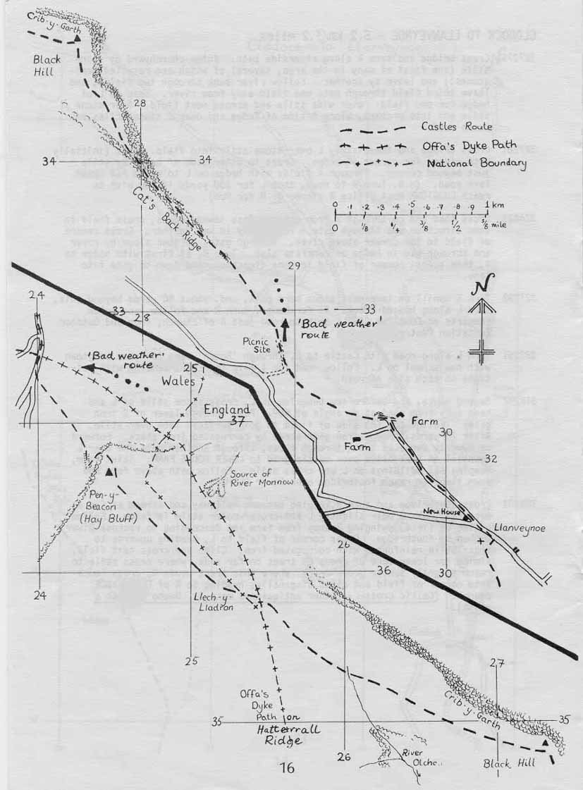
The Offa’s Dyke Castles Alternative is a route from Monmouth to Hay-on-Wye that follows a line further east than the Offa’s Dyke Path. It gives an excellent alternative to Days 17 and 18 of the End to End Trail, particularly if you have walked Offa’s Dyke before and would prefer to follow a different route. The Castles Alternative was originally published by the Offa’s Dyke Association in 1980, revised in 1987 and 1994, and the description is given below with their permission, with a few updates of my own (including minor updates to the foreword). The maps are the original ones from the Offa’s Dyke Association booklet, scanned in and then amended where necessary, so my apologies for their presentation. I hope to get time to re-draw them at some point, but don’t hold your breath. To get bigger maps, save them as separate images and print them whatever size you want with a graphics package. Copyright of the original text, maps and diagrams remains with the Offa’s Dyke Association, and it may not be copied without permission.
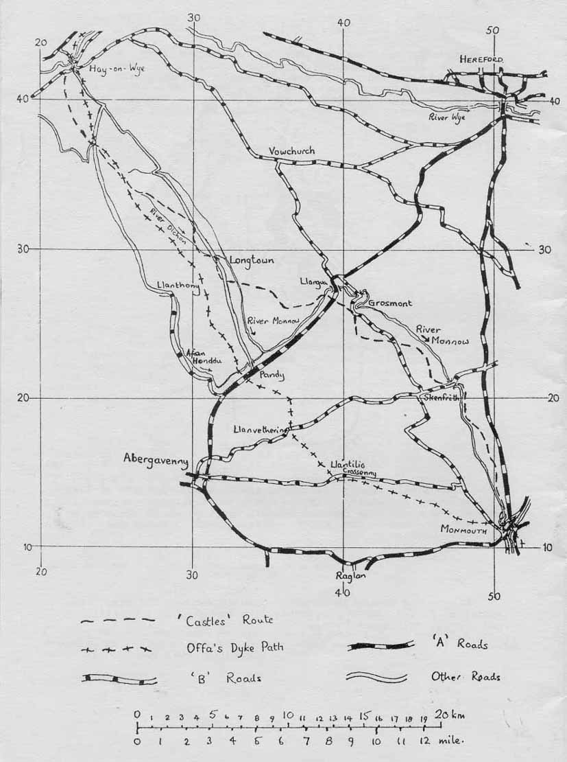
Overview map of the route
Foreword to the original booklet to the Offa’s Dyke Castles Alternative
This name is used to describe an alternative (not waymarked) to the official Offa’s Dyke Path route between Monmouth and Hay-on-Wye. Existing rights of way are used, but although there is evidence that these paths are receiving increasing usage, the route is seldom as clear as the official route: care must therefore be taken to keep exactly to the route, especially near farmyards and when crossing gates and stiles. Remember to act responsibly when crossing farmland so that others walking this route in the future may be welcomed. This route misses out White Castle and the Hatterall Ridge, but these exceptions are amply compensated for by the castles at Skenfrith, Grosmont and Longtown and the spectacular Cat’s Back Ridge above Llanveynoe, and by the use of generally higher and more interesting terrain. We think many walkers will enjoy this route and we hope that these notes and maps will make its following more practicable. The maps are diagrammatic and should be used with the accompanying notes and the relevant OS maps. We recommend the use of sheets 161 and 162 of the 1:50,000 OS Landranger maps (and a compass to help you use them!): the relevant 1:25000 Explorer sheets are OL14 – Wye Valley the Forest of Dean, 149 – Hereford and Ross-on-Wye, and OL13 – Brecon Beacons Eastern Area.
A route between Hay and Monmouth via the Border Castles is briefly mentioned in Frank Noble’s early Offa’s Dyke guide, and this was followed by his initial YHA groups in the early 1960s. The route was surveyed in 1975 by a team under the direction of Ernie and Kathy Kay, and a set of notes were published following survey. Mark Richards’ guide includes maps of the 1975 survey route, from which this route deviates but little. Our thanks are extended to these three sources of much aid and advice.
John Allder, Iain Liddell, April 1980.
Additional foreword to the 3rd Offa’s Dyke Association edition, 1987
The following notes are a
rewrite, based on a complete re-survey of the route, of the description
worked out in 1980 by J.A. and I.L. This new survey was carried out by
the undersigned during April to June 1987. Part of the route was also
checked by Eve Tovey and her colleagues and they have produced the wet
weather alternative which avoids the Cat’s Back and Black Hill.
Kathy and Ernie Kay, June 1987.
And one more for the online edition, 2007!
I walked most of the route in
2002, and have updated the description and maps to bring them up to
date as at that time. I haven’t rechecked most of the route since, but it
should still be more or less correct – email me
if you find anything needs changing. The sections I haven’t checked are
the final part of the route into Hay, from the road below Hay Bluff
(both routes), and the wet weather alternative route. These sections
remain unchecked since the 1994 revision to the Offa’s Dyke Association
booklet.
Andy Robinson, February 2007.
Monmouth to Moyle’s Cross – 5.5km/3.3 miles
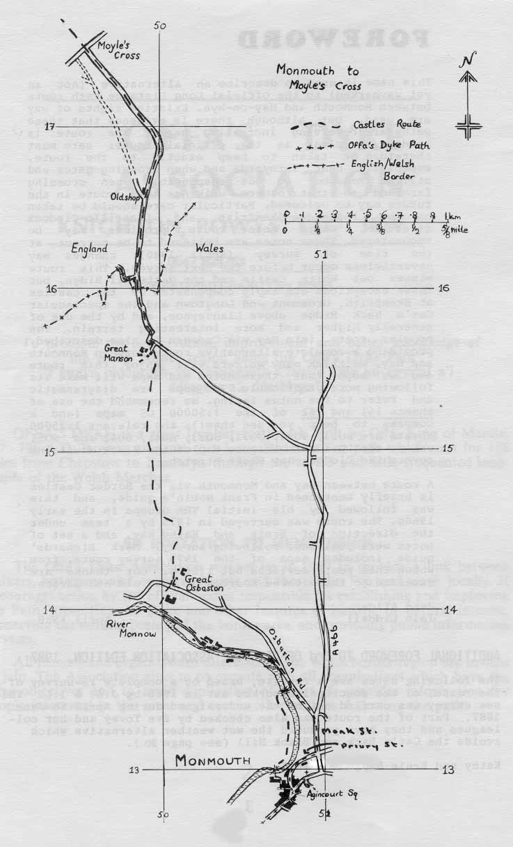
Start at GR508129. From
Agincourt Square, turn up Castle Hill (the lane to the left of
Woolworth’s store) – this leads to Monmouth Castle. Turn right behind
Woolworth’s and down steps to cross the River Monnow on a new bridge to
reach playing fields. (N.b. this bridge is M.O.D. property and isn’t
dedicated to the public, i.e. it can be closed.) Head right along the
river bank to the end of the next bridge – to Vauxhall Training Camp.
N.b. should the first bridge be closed, the alternative street
route (see map) is via Priory Street, Monk Street and Osbaston Road.
GR508134. Go through railings and right (i.e. over the bridge) to the
road at the entrance to Vauxhall Training Camp. Go left along the road.
(The map shows the alternative route by road from Agincourt Square to
this point.) Note the old mill with the remains of a weir and leat on
the left.
GR507136. Fork left (Forge Road) beside the river at the old weir;
follow the road past all the buildings. At the end of the road go into
the field and keep straight on to reach the river bank at a large weir.
Follow the riverbank, crossing a small footbridge. Beyond a field with
a couple of fruit trees in it (below a house), cross a stile into an
orchard and turn right up its edge on a clear path, through an iron
gate in front of a barn and out to the road by another iron gate.
GR501141. Head slightly left and across the road to take Manson Lane
(footpath sign). Go through the gateway ahead into the field, then keep
the field boundary on your left, to turn left (gap) well before the end
of the field.
GR502144. Cross a sunken lane on the left by a broad track and continue
downhill. Cross a stream. Go up a holloway and along the right edge of
a field to its top – cross a stile in the corner and continue with
woodland on your left. At the top of the field cross a stile a few
yards to the right. Aim just right of both the crest of the next field
and the barn visible ahead, then cross a fence on the right, by an
electricity pole. Aim across the corner of the field to reach the Great
Manson farm track by means of a gate just right of all the main farm
buildings. Turn right up a track and left along a minor road.
GR499156. Follow the road to Old Shop and Moyle’s Cross. (A potential
alternative route marked on the OS map leaving the road at Old Shop on
a track left of the cottage – not through its garden – was still not
followable in 2002. It would, after 100 yards, continue on a shelf in
woods just above fields on the left. It would then go through a gate
and continue on a shelf at the edge of the field, and through a further
gate to meet a surfaced drive. The upper fork then leads to the road;
turn right to the junction at Moyle’s Cross).
Moyle’s Cross to Skenfrith – 8.1km/5.0 miles
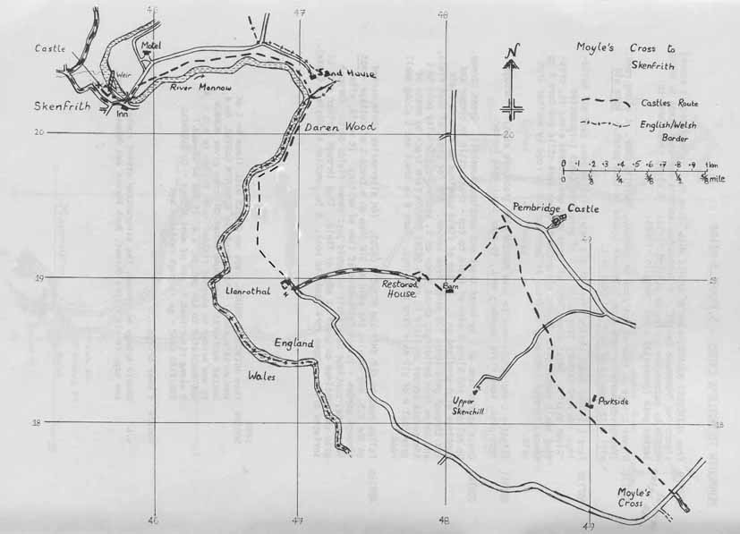
GR496175. Go over an iron gate ahead into a field; proceed with a hedge
on your right. After two fields, cross the remains of a gate in a
holloway in the right corner of the field. Climb the field, with
a hedge on your right, then cut across left to a stile 50 yards left of
the field
corner. Cross and continue in the same direction with the hedge now on
your right. Cross another stile in the next field corner and keep
straight on, passing well to the left of the farm
(Parkside), to go through a gate at the top corner of the large field.
GR487186. Turn right, keeping a line of hawthorns (an old hedge) on
your right to cross the drive of Upper Skenchill Farm. Go through a
gate opposite (or cross the stile) and descend on a path through a wood
(Sheephouse Brake) to a wooden gate to the right at its end. (The path
through the wood is overgrown, especially by bracken in summer, but it
can be followed with the help of some marker posts. Take care at the
start not to go too far to the right.)
GR485190. Cross the field at right angles to the high-voltage power
lines and go to a gap at the furthest corner. (To reach Pembridge
Castle continue on right of next field to a road, turn right and follow
the road for 400 yards). To continue route to Skenfrith: Do not go
through the gap, but swing left and contour across the right side of a
large field, under power lines, to a large barn, reached at the end by
going through a gate in the fence on your right 80 yards before the
barn. Do not go through the gate just beyond the barn, but swing right
downhill with a fence on your left. Near the bottom of the slope
pass a restored house on your left (over a fence) and join its drive to
cross the stream. Continue on this drive for 2/3 mile to Llanrothal, at
the end of the drive (gate) turning right along the last few yards of road into what used to be
Llanrothal Court farmyard but was, in 2002, being converted to housing.
(Llanrothal Church – mediaeval – is just to the left along the road at
this turn).
GR469189. Go straight on past the buildings (on your left), down a
slope and straight across the field ahead (no visible path) to a stile
in the middle of the opposite side. Cross and go half right in the next
field, now on a clear path, and through a gap in a hedge. Continue in
the same direction (north, parallel to the river) in the third field,
still on a clear path, to join the bank of the River Monnow as it bends
to the right. Follow the river
to enter Daren Wood over a stile by a gate. The path is soon by the
river again. At a sharp lefthand bend in the river cross a tributary
stream on a footbridge. Continue along the bank of the Monnow, at first
by the edge of the lawns of Sand House to a footbridge and stiles, then
through meadows by the river for 2/3 mile into Skenfrith; there are
stiles and footbridges where necessary.
GR459203. Cross a stile to the road at a sign (“Tregate Bridge 6.5km”),
cross the bridge and enter the village, the Bell Inn on your left.
Skenfrith to Grosmont – 9.0km/5.6 miles
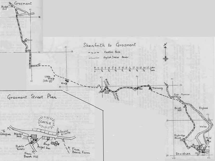
GR457202. Turn right at the
castle (which should be visited), passing the church on your right and
continuing on the road to Drybridge House after crossing a small stream.
GR453205. Turn right in front of Drybridge House and follow a surfaced
lane (“No Through Road”) towards Birch Hill Farm, with views to the
River Monnow down to the left.
GR454213. In just over 1/2 mile, just before the first farm buildings,
go right over a stile, then keep left. Cross two stiles through the
garden,
between the rightmost building and a pond, to a track, and descend to a
stile above the riverbank, continuing in the field above the river.
This bit is waymarked for Skenfrith (Three Castles Walk). The path
descends almost immediately to a “footbridge” across nothing on its way
into trees and a stile. Over this, cross a muddy patch on a boardwalk
and then a stream.
Then, keeping a hedge on your right, make directly for Trevonny Farm,
visible ahead, through three fields.
GR444219. In the fourth field go on to a stile in the field corner,
then continue, hedge now on your left, turning left on a track through
a gate. This avoids Trevonny farm by following a permissive path, with
the farm to your right. Turn left along the farm access road, past Box
Farm to the B4347.
GR433218. Head right along the road for 350 yards, then go left at a
junction just before a postbox. Soon you will pass White House Farm on
your left. 300 yards from the junction (at the summit of the road) fork
right uphill on a track (stile and iron gate), doubling back right
immediately after the stile (not through the second gate straight
ahead). Follow the track for about 40 yards, then at the first
opportunity turn left off the track into the field above (footpath
sign). Climb the field (no visible path), gradually converging with the
line of trees to the right (on a bank). At the top corner of the field
cross a stile in the fence (at the edge of the trees), and climb up
right immediately onto the bank to follow a clear track along the top
of it, with a fence on your right. A stile takes you into the corner of
the next field: continue straight on, now with the fence and line of
trees on your left. Cross a stile in the field corner then continue
straight on (no visible path), cutting across the bottom of the next
field to join a fence. Follow it, now with a wood on your left. A clear
(but sometimes muddy) track appears at the next field corner. Follow
the track straight on when the fence on the left turns away. A modern
barn on your right is all that remains of Upper Graig Farm. Continue
through a gate on a track to the far side of the next field.
GR416224. Go through the righthand of two gates then
diagonally up right to a stile visible at the opposite corner of the
field (keep left of the
bottom end of a tongue of woodland). Cross it and head left along a
farm track (this is soon enclosed). At a sharp lefthand bend the
track
begins to become surfaced.
GR409225. Turn right through (gate and stile) and straight on down a steep track.
After 600 yards, the track bears sharp left, then descends past Barns
farm. Keep straight on to the left of the main buildings and farmyard
and follow the surfaced drive down, through a gate to the road beside a
stream.
GR406241. Go left over the stream on a footbridge and up a steep path
to Grosmont village; turn left up the road to the Market Hall.
Grosmont to Llangua (A465) – 2.4km/1.4 miles
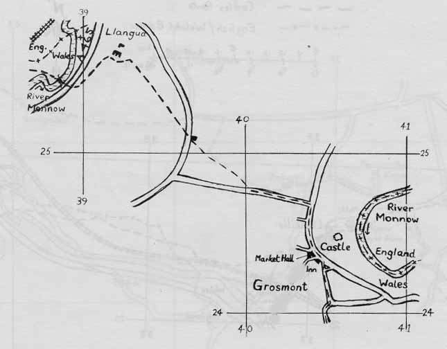
IMPORTANT UPDATE, May 2019. The footbridge over the River Monnow at Llangua is no longer there, and the footpath is consequently “temporarily” closed, so you will have to follow an alternative route from Grosmont to Llancillo. I have put together the alternative route from looking at OS maps, and have not yet had time to go down to check it works OK, so let me know if you have any problems in following it. The revised route is text only, I haven’t yet revised the maps. My thanks are due to Paul Hutchinson for letting me know about the footbridge.
REVISED ROUTE
GR405244. Continue on the main road through the village past the school and the road signed left to Abergavenny. In 200 yards turn left and cross a large field NNW then NW towards the buildings at Kingsfield. Cross into the next field.
GR401251. Turn right (don’t go ahead to the buildings) and head NE for 800 yards until you are approaching the River Dore.
GR407256. Turn left and follow the river, diverging from it as you approach the road at Monmouth Cap.
GR394263. Turn right along the road, joining the busy A465, and cross the river. Take care along here as the traffic is dangerous. As soon as you have crossed turn left on the riverside path.
GR388263. The path meets a track below Rowlstone Park Farm. Follow the track, which becomes a road, until it turns sharp right at Bridgemoor Farm.
GR383262. Go straight on when the road turns right, following the access road ahead. Keep on SW through the buildings and a path continues, crossing a footbridge and keeping more or less SW to the left of a wood and on to Sunnybank Farm.
GR377257. Continue SW past the farm, then just before you reach the railway there is a stile on your left which is where the original line of the route joins again. Don’t cross it: jump to beyond the bracketed section of route description, heading across the field towards the railway.
I have left the original route description in place in the hope that the bridge eventually gets replaced. For now, ignore all the description in square brackets.
[GR405244. Continue on the main road through the village to the school, then turn left along the road signposted “Abergavenny 11”. Continue for about 600 yards, then immediately beyond a large corrugated iron building to the right, cross a stile on the right into a field. Cross diagonally and over a stile (above a gate) to reach a green track below an orchard to the left; follow this until it fades out, then continue to a stile into the road just left of a house. Turn right and proceed down the road for about 150 yards.]
[GR396253. A path enters the second field on the left over a stile; head down the field to a gate in the middle of the hedge and continue down with a fence and holloway, with a stream on your right, to a gate at the end of the next field. Continue down to a gate, turning left just before it to follow a track along the bottom of the field. Cross a stile in the corner. Go half-left here to cross two more stiles into the corner of another field (ignore all the gates). Climb left to the top of the field to the right of another holloway. Using a large solitary tree as an initial bearing, descend to a narrow stile in a fence to reach the A465 just south of Llangua church.]
Llangua (A465) to Clodock – 8.0km/5.0 miles
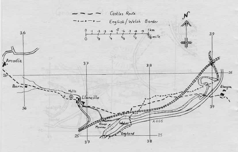
[GR389255. Cross the A465, go over stile then the River Monnow on an iron footbridge. Take the path trending left from the bridge past a meander in the river to an old gateway near the river, and diagonally right across a field to cross a railway (it is not easy to cross the track formation – take care) by stiles at the end of field. Proceed at a right angle to the railway with a small stream/ditch on your left. At some times of year you could find this field and the next hard to cross due to crops, as the right of way isn’t walked much. Before the end of the field, cross the ditch and circle the right edge of a large field. 100 yards before you’d reach the railway again, go over a stile on the right.]
Back on the original route
Cross a field to reach a stile crossing a hedge beside the railway embankment on the left (do not cross the railway via the gate to the left). Follow the embankment to a stile in the left corner of the next field. Head diagonally right across two fields – gate between – to Llancillo farm and cross the stream and stile below and to the left of the farm buildings to reach and go right on the farm drive.
GR368254. Cross a stile to the left of a barn to the left of the farmhouse and go up the field to Llancillo church, passing to the left of the motte. Go through the churchyard, over a stile and immediately another one across a small orchard. Continue along the lower edge of a field on a high terrace above a stream on the right for two fields, with a stile between them. Cross a small stream and go through a gate. Head up the centre of the field, making for a barn and tall tree on the horizon. Cross a stile by a gate to the right of a barn and keep a hedge on your left for two fields. At the end of the second field go over stile and footbridge: head diagonally right across the field to a gate into a road below and left of Arcadia farm.
GR356262. Turn right along the road, forking left just beyond the
Arcadia farm buildings onto the drive leading to Upper House farm. Just
before the farm, bear right over a gate and follow a sunken lane,
keeping the farm on your left. Continue at the end of the track (stile)
and through a field with a hedge on your right. Go through the gate
ahead into a young plantation, still with the hedge on your right, then
at the top of the plantation turn left, then right in
20 yards through an iron gate. Cross a field, keeping the hedge on your
right to reach Pen-yr-Heol farm drive. Go left along the drive to the
road: there are fine views towards Hatterall ahead and Skirrid
half-left.
GR350268. Turn left along the road, and, after 150 yards, turn right up
Trelandon farm drive. Turn left opposite the farmhouse and then right
through two gates to pass round the left side of a newish barn.
Continue up a farm track with a stream below on your right to reach a
stile in the hedge. Cross and go straight on with a dry “valley” and
fence on your right to a stile at the top of the field. Go straight on
across the next field (footpath sign) to a stile, then across the
next as well to join a hedge at a corner. Keep straight on, now with
the hedge on your left.
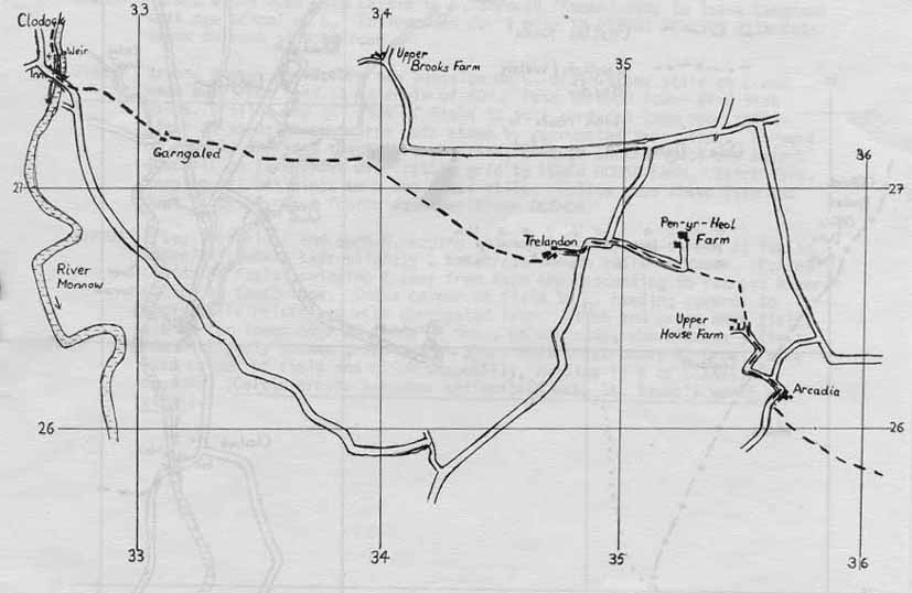
GR338272. Follow the hedge round to the left, passing through a gate
and then immediately right through a gap. Keep the hedge on your left
for a few metres to another gate. Go through and descend (no path),
keeping to the right side of the field.
(Hatterall ridge is ahead, Longtown and Cat’s Back are half-right). At
the bottom of the field, a track is well-defined to the right of an
outcrop. Head down the righthand edge of the next two fields and then
through
Garngaled farmyard (no longer lived in). Continue downhill slightly to
the right
(aim for the church seen below), and follow the lefthand side of the
fields as you descend (waymarks, stiles and gates) to reach a gate left
of a bungalow. Go through and down the right side of
field to reach a gate and stile in a holloway. Go through the gate
(ignore the stile to the right) and follow the track down to the road
by the
bridge at Clodock. Turn right along the road.
Clodock to Llanveynoe – 5.2km/3.2 miles
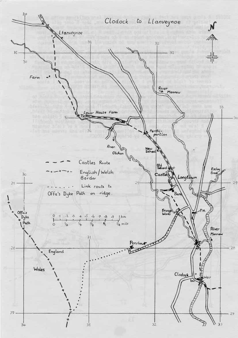
GR327275. Cross the bridge
and turn right along the riverside path. Enter the churchyard by a
stone stile (the first of many in the area, several of which are
recycled headstones!), and leave by another. Follow the river bank
by a garden and through one field into another, leaving the second field through a gate one field
away from the river. Keep to the left of the hedge for one field, then
cross a wide stile and go across the next field. Cross a stone stile
into an orchard and turn left, crossing two stone
stiles to reach a road.
GR327281. Cross the road bridge and immediately turn left over a stone
stile into a field. Make for the corner of the hedge, initially
following the river. Cross to other side of the hedge by a stile just
beyond the corner. Go through four fields with a hedge on your left to
reach the Pen Rhewr farm road. (To visit Longtown village turn right
along the road to a T-junction. Turn left here for the post office and
shop, 300 yards away, or right for the pub).
GR324285. Cross the road and go through two iron gates. Pass a sewage
works, cross a field in the same direction and cross a stile. Cross the
centre of a field to the far corner
above the river. Go through a gate, down a slope by the river and
cross a stile in a hedge on a concrete slab. Turn right, at first with
a hedge to your right, then across the corner of a field in the same
direction, and down to a stile by a gate into a lane.
GR321288. Turn right uphill on a lane past a stone barn on your right,
and, about 40 yards beyond this, turn left along a hedged track. At a
farmhouse, turn right and follow a lane below the ramparts of Longtown
Castle (on your left) to join a road just right of the church, shop and
Outdoor Education Centre.
GR322291. Turn left along the road, with the castle to your left,
through the “Roman” camp to leave Longtown with a new school on your
left. Follow the road for 1/2 mile to Perthi-Pertion, with cottages on
each side of the road.
GR318297. Beyond the house, and before a new bungalow on the left,
turn left at the second footpath sign pointing left (through a gate
into a field), and head away from the road at an angle
of 60 degrees (bearing 290 degrees). Pass through the lower of two iron
gates. Follow the top
(right) side of a field to join a surfaced lane over a stile. After 20
yards, go through an iron gate ahead. Go
forward on a roughly surfaced track through trees to another gate, then
turn right before the gate, on a track with a fence on your left,
parallel with the drive to Lower House Farm. Cross a stile in a fence
and continue in the same direction in the edge of a deciduous wood,
with a ditch and fence on your left. Leave the wood at a gate and
continue along an old sunken grassy lane with a fence now on your right
and the farmhouse now below you on the left. Descend to cross a stile
near the farmhouse, and follow the path down the slope to reach a
footbridge over the River Olchon.
GR309303. Cross the footbridge and turn right, keeping between the
holloway and stream as far as a waterfall, where you bear slightly left
and cross a wooden stile in a fence. Follow the left side of the field,
cross a stile in a fence ahead, then swing right away from the farm, descending to recross the River
Olchon by a footbridge. Cross the corner of the field to the left,
heading upwards to cross a stile. Climb
and cross the next field, aiming for the lower edge of a group of trees
on the far side, where you cross a stile to reach a slightly sunken
green track. Where this track bends right, cross the stile into the
corner of a field and climb diagonally, heading to the right of
Llanveynoe church. (Celtic crosses and other antiquities make St
Beuno’s worth a visit).
Llanveynoe to Hay Bluff and Gospel Pass Road – 9.9km/6.2 miles
GR304313. Leave the field at
a gate and turn L along the road. Take the right fork at Papillon Cottage and
follow the minor road to its end at a farm.
GR295324. Go through the gate straight ahead; after 20 yards (wet) go
through another gate on the left. Climb up through trees to cross a
stile at the top of them, cross a small field to cross another stile by
a gate into more woodland. Follow a rising track through the trees.
Keep right at the top of the wood to cross a stile into a field corner.
Follow a path along this narrow field to reach a minor road:
follow this to the right for 150 yards to reach a car park and picnic
site. (See below for the “bad weather” route).
GR288328. Cross the stile by the car park onto the hill. Aim half left upwards onto and over the rocky
top of the Cat’s Back Ridge, keeping to the right of the ridge as it
broadens and eventually reaching the trig point on Black Hill.
GR275348. Bearing slightly left keep to the top of the ridge (Crib y
Garth) until the head of the Olchon valley is reached on the left.
(N.b. in wet conditions the path rising from the Olchon valley may be
followed to here.) Trend right and make for the main north-south ridge
(compass bearing 300 degrees), rising gradually all the time and
keeping near the right edge, overlooking the valley to the east.
GR253359. Reach the main north-south ridge just north of a 100-foot
drop bearing the route used by most Offa’s Dyke Path walkers off
Hatterall Ridge by Llech y Lladron (The Robber’s Stone), a rock outcrop
on the left. (Just before this you cross the official Offa’s Dyke Path
route – paved along this stretch – which makes it’s way towards Hay to your right. It crosses the shoulder of Hatterall
Ridge, passes the source of the River Monnow and descends the east face
of Hay Bluff by a rhiw (a narrow grooved path), crossing two streams
and traversing the heathland at the right edge of gorse bushes to meet
the Gospel Pass road. This route is, however, little used as most ODP
walkers proceed to Hay Bluff). You, on the other hand, should swing
right and continue in as straight a line as the peaty morass will allow
to reach the summit of Pen-y-Beacon (Hay Bluff).
GR244367. Swing right and then left down a rhiw descending the
northwest edge of the bluff: at a group of rocks go sharp right and
down a track leading to the Gospel Pass road adjacent to the car park.
Turn right along the road for 400 yards to where the ODP rejoins from
the right.
GR240377. This point marks the end of the Castles Alternative route –
the Offa’s Dyke Path via Cadwgan may now be followed into
Hay-on-Wye. However, there is also the alternative former ODP route via
Hay Common into Hay. Both of these are described below.
Gospel Pass Road to Hay-on-Wye – 5.8km/3.8 miles

This is the former official ODP route via Hay Common.
GR240377. After going 400 yards along the road, 100 yards before a road
junction, go down a track on the left to reach a T-junction of roads
below. Go forward on the green track beside the road opposite (or on
the road itself). Go forward on the road over the cattle grid and
immediately take the right fork.
GR230397. In 1 1/4 miles (at a point with fine views to Hay) the road
bends sharp left at Pen-yr-Henallt. In a further 1/4 mile, at a
horseshoe bend in road, where it swings right for the second time, go
over a stile to the left of a gate on the left and go forward by a line
of old trees, soon passing a long barrow to your left (an exposed stone
chamber). Near the end of the field swing right to a stile by a cattle
trough in a dingle (beware of going too far down to the right). Over a
stile, go up and immediately over another stile into the wood. This
leads into a field: go straight across, contouring, through a small
patch of wood, across an arm of a field, into another larger wood.
GR224403. Cross a boggy area and swing right downhill at a large tree.
Head out into the field, pass a cottage (ruined) through a gate to the
right, then go left then right round the field to a stile by a gate in
the hedge on the left. Go down across the field heading for Hay Church
seen in the valley ahead; down left of slope with bracken and gorse,
then at the bottom this leads to an enclosed track. Follow the
right side of the next field, soon swinging to the right with an iron
fence to the right. Where the track swings left by a confluence of
small streams, go through the gate below (not the kissing gate to the
field above). This soon leads to a footbridge and down a dingle,
crossing and recrossing the stream. Follow the track down to the B4350
and follow this right into Hay town centre.
Gospel Pass Road to Hay-on-Wye – 5.8km/3.8 miles
This is the official ODP route via Cadwgan
GR240377. Continue down the road for a further 1/4 mile.
GR240382. Where a wall leaves the road to the left, fork left along an
ill-marked track across grass midway between the wall and road.
GR238395. Nearly a mile further on, the track converges on a wood and
goes through a gate into a sunken track. Ford a stream, then pass
Cadwgan farm on your left.
GR237397. Beyond the farm, go down the lane and cross a stile on the
right, heading diagonally across to the lower side of the field just R
of an old incomplete hedge boundary. Take the track sloping down
steeply to the right, then swing left and go down to cross a stile into
a lane just right of Upper Dan y Fforest farm. Turn left, then
immediately right over a stone stile. Continue straight down over three
more stiles, with a stream to your right, then go right over a stile
and footbridge. Turn left and continue with a stream on your left to a
stile and road.
GR237409. Turn left along the road for about 400 yards, then cross a
stile on the right. Go diagonally left across the field to a stile in
the corner, and forward to Cusop Dingle, with Dulas Brook on the right.
Go through a gate, over a footbridge, and continue with the main stream
on your right. The path continues straight on through kissing gates,
with the buildings of Hay visible ahead. The final kissing gate
leads to a narrow alley right of a car park.
GR233423. Reach the B4348 opposite the castle at Hay-on-Wye.
Bad weather alternative avoiding Black Hill etc
This alternative route runs
from the car park south of Black Hill to the Gospel Pass road. Follow
thr route described above from Llanveynoe to the car park, then…
GR288328. …from the car park cross the stile and follow the well-defined track along the
foothills.
GR278357. A track on the right soon leads down to reach Craswell road
and the Bull’s Head public house, but your route is ahead through a
gate – the enclosed track can be very muddy. There are several streams
and no bridges, but the track is easily negotiable. Continue in a
north-westerly direction along the track through fields and wooden
gates. After the 8th gate keep straight ahead at a crossing of tracks.
GR267364. Cross a stream, bear right along a wider path which swings
left ot continue northwest (a lane on the right leads back to the
Bull’s Head). Keep right after passing through a gate near a sheep pen
on the right.
GR262366. There is no footbridge, but the ford is easy to negotiate (as
is another at GR258368). Cross open land keeping within a short
distance of the wire fence on the right. When this fence turns sharply
right keep straight ahead – there is no single clear path.
GR243375. A short distance after passing old some quarries on the
right, the path is joined by the Offa’s Dyke Path coming off Hatterall
Ridge.
GR240377. In 1/4 mile the Gospel Pass road is reached and either of the two routes described above can be followed into Hay.
Castles Alternative – Historical Notes
These notes describe briefly
some of the buildings to be seen on the route. Many have their own
guides or are described in more detail in standard guides to the area.
Pembridge Castle
is an example of a small, private border castle. It was held by the
Wake family up to the 14th century, and then by the Mortimers. The
earliest feature is the northwest tower which is early 13th century.
The gatehouse and curtain wall are late 13th century.
Llanrothal, now only a farm near the Monnow, was once a village and still has a church with a Norman nave and also 13th century features. Only the east end is in use.
The route includes two of the Castles of the Trilateral, held by the
Duchy of Lancaster as a check to the growing power of the Lords
Marcher. The third (White Castle) is on the Offa’s Dyke Path north of Llantilio Crosseny.
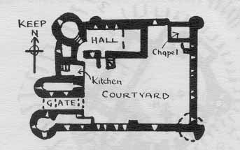
Skenfrith Castle
was probably built by the Justiciar, Hubert de Burgh, 1219-1232, and
then passed to the Crown at his fall. The castle has a moat fed by the
Monnow, a curtain wall with a simple gate and drum tower, and in the
middle a round three-storey keep on an earlier motte, late 11th century
or early 12th century.
Skenfrith Church is early English, has a perpendicular tower with a timbered belfry and contains some good woodwork inside.
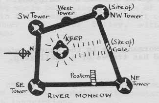
Grosmont Castle
is mentioned in 1182 but the earliest masonry is early 13th century,
comprising the Great Hall and the curtain wall to the southwest of it.
Hubert de Burgh built the gatehouse and three four-storey drum towers,
1220-1240. Further apartments were built c1330, including the elaborate
chimney, and a drawbridge was added to the gatehouse, from which the
pit survives.
Grosmont was a corporate
borough until 1860, is the centre of a complex road network, and has a
little town hall with an open market area at ground level. The church,
which is large and much of which is now unused, is cruciform with a
south chapel funded by Henry III’s queen, and has an octagonal tower
with a spire.
Llancillo has Norman work in the church, whose chancel has tufa quoins. The mound has traces of a shell keep.
Clodock has a church with
Norman nave and chancel arch, and 17th century woodwork including a
3-decker pulpit. The watermill retains the large wheel of 1868 and
other machinery.
Longtown, the ancient borough
of Ewyas Lacy, was the centre of the de Lacies’ territory until 1240.
There are references to the borough in the 13th century. The church
dates nowadays mostly from 1868, but has a Decorated E window and a
timber chancel roof of 1640. It was built as a borough chapel because
the parish church was too distant. The market place is in front.
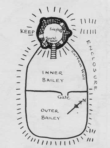
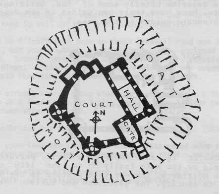
Longtown Castle
may be the earliest round keep in England, being late 12th or early
13th century. It stands on an earlier Norman motte, the whole occupying
one side of a large rectangular area of uncertain date (Roman? Saxon?),
part of which was adapted to form an inner and outer bailey, with a
cross wall with gatehouse between.
Llanveynoe church is of
predominantly recent building, but it contains carved panels, probably
11th century, of a crucifixion and a cross with inscriptions.