Section 3
Most of the changes here are minor, but on Day 22 I have rerouted some of the Trail for the new edition to avoid fields where a bridleway has been repeatedly blocked. I’ve clarified some complicated bits on Day 28 too.
Day 20 – Knighton to Craven Arms
- Map 1: Paragraph 3. As you descend the “old sunken lane” go through the gate on the left (fp sign) and cut diagonally down on an old track to cross the stream and the valley access road.
- Map 2: Paragraph 1. There is a new fence on Stow Hill: use the gate.
- Map 2: Paragraph 2. The path has been re-routed above and right of Lower Lye.
- Map 3: The Bird on the Rock/Rocke Cottage tearooms at Abcott has sadly closed down.
- Map 4: Paragraph 1. If you have the first printing, the route in that edition when it first leaves the road doesn’t follow the right of way, as that used to be blocked. It has now been reopened, and the path is on the other side of the hedge most of the way to Clapping Wicket. This paragraph should now read: “Continue along the road past a right turn & then a crossroads. Shortly after this, opposite a farm access road, turn right between two adjacent gates & follow an overgrown lane then a field edge diagonally up the hillside to the top field corner. A stile leads to another short overgrown lane which joins the access track to the cottage at Clapping Wicket. Go through a kissing gate to the left of the cottage then go ahead on the main track into Stoke Wood. When the path nears the edge of the wood look out for a marker post & a stile on the left.”
Day 21 – Craven Arms to Ironbridge
- Map 2: Paragraph 2. The point at which you need to turn right is no longer clear, since a new path has developed that goes straight on here. This paragraph should now read: “Eventually a short stretch of fence appears on your right, & soon after this a major path turns right alongside pines: follow it to the road & cross into a small car park. Pick up the path in the far corner of the car park & follow it just inside the edge of the wood, again along the top of the escarpment.”
- Map 4: The Wenlock Edge Inn (marked on first printing copies) has closed down.
- There is no longer a bank in Much Wenlock, but there is a cash machine at the garage you will see to your right as you approach the town centre.
- Map 6: When you leave the road after the priory, take the right fork when the path divides.

Day 22 – Ironbridge to Penkridge
- Map 1: Due to landslip reconstruction work and the rebuilding of the Half Moon Inn it is now more pleasant to stay on the “main” road past the Tile Museum, then fork right on the line of the old railway once more. Leave it when it crosses a tarmac road, and descend this to the Boat Inn.
- Map 1: As you climb by the Hay Incline, if the path going right is too overgrown to follow then you can continue up the incline to the top then turn sharp right (gate). Descend this path a little, then take a path up left into the wood (back on the original line).
- Map 3: Paragraph 1. The path has now been diverted right round the grounds of the first house, but the line is pretty obvious.
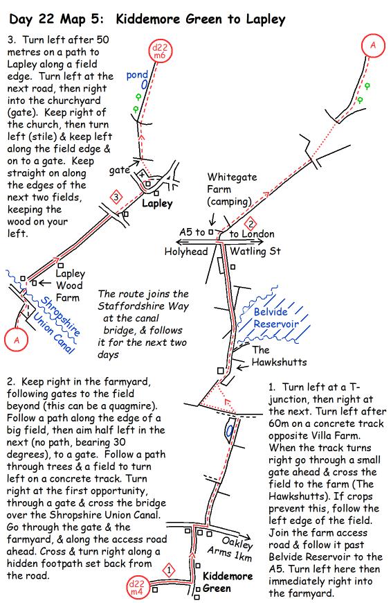
- Maps 4 and 5: The bridleway across the fields approaching the A5 has been repeatedly blocked by crops in the summer months and this has given a few walkers problems, including me. I have rerouted this section for the new edition, and I’d recommend you follow the amended route. Here are maps for the amended Day 22 Map 4 and Day 22 Map 5:


- Map 5: There is no longer a pub in Lapley.
- Map 6: Paragraph 4. At the point where the hedge turns left, there is now a track straight on, with a fence on its left. Turn left with the hedge, don’t go straight on here.

Day 23 – Penkridge to Abbots Bromley
- Map 1: Paragraph 2. You no longer cross a stile. Now you stay in the field, with the hedge on your left.
- Map 1: Paragraph 3. “Turn right at the corner…”: you still do this, but the path now has the hedge on its right, not left.
- Map 1: Paragraph 4. On leaving Bednall you keep RIGHT at a fork, not left. There was a mistake in the first printing: it is clearly right on the map though.

Day 24 – Abbots Bromley to Thorpe
- Map 3: After crossing the A50, many of the fences between here and the river have gone. Head across the meadow on 20 degrees past a post.
- Map 8: Paragraph 3. The descent into Thorpe can be confusing, particularly at the end of a long day. I’ve rewritten this paragraph to try to make it clearer: “Climb up by the wall to find a stile into a walled track. This leads to a road (Dale View): turn left then right down a lane (tarred initially). When the lane turns sharp right follow the footpath straight on downhill past the churchyard until you cross a small footbridge. Turn left here (slightly uphill across grass) to a road. Turn left & follow the Ilam road round to the right. A footpath sign on the right indicates the path to Dovedale.”
Day 25 – Thorpe to Youlgreave
- Map 3: Last time I visited there was a clear path across the field cutting off the corner of Candlemere Lane. If it’s there, then use it. It’s a public footpath that starts at a gate in the field corner, and it leads directly to the stile and continuation of the Trail (at paragraph marker 2).
Day 26 – Youlgreave to Hathersage
- Map 1: After crossing the River Lathkill and climbing up to a gate into a field, the fence that was on the right is no longer there, which can be confusing. Head east across the field, then bear a bit left to a small gate.
- Map 2: There are new fences on Calton Pastures after going between the two plantations, so two more gates to go through. The route is the same.
- Map 4: Finding the right path up to Carl Wark can be confusing. The route in the old guide follows paths that are no longer all clear on the ground in the boggy area by the upper part of the stream. The easiest way now is to start up Green Drive from the A6187, fork left off the track to cross the stream on boulders, start up the path that heads to the right end of Carl Wark, then fork left off this path after a few metres on a smaller path that continues clearly and heads up to cross the shoulder of Carl Wark further left.


Day 27 – Hathersage to Dunford Bridge
- There is no longer any accommodation at Dunford Bridge, as the pub closed down some years ago. See below for some options.

Day 28 – Dunford Bridge to Hebden Bridge
- Map 1: At the end of this map page you cross a road. This is White Gate, and there is now a campsite at the road crossing, and a B&B (Coddy’s Farm) a short distance down the road to the right. Their websites are whitegateleisure.co.uk and coddysfarm.co.uk.
- Map 2: Leaving Holme, what used to be signed “School Lane” is now signed “Meal Hill Rd”.
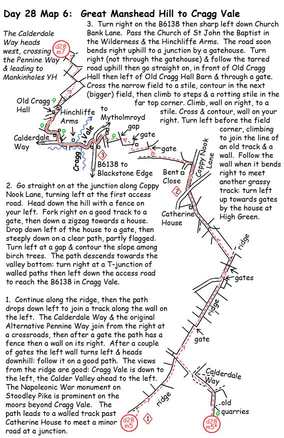
- Maps 7 and 8: Routefinding is a bit intricate around here. The end of Map 7, after Old Cragg Hall, is not good enough, and must have confused people. Additionally it doesn’t quite follow the right of way, as that wasn’t possible when I first walked the route. There is a clearer route now, although even now it doesn’t quite follow the right of way shown on Ordnance maps. On Map 8 there is a very wet section crossing Bell House Moor, and there is actually a slightly less wet option up the slope. After that, finding the path across Erringdon Moor is difficult, but it makes the crossing a lot easier if you do find it. I’ve done my best to make both these maps clearer for the new edition. These two pages are renumbered for the new edition, but the maps below are direct replacements for Day 28 Maps 7 and 8 in the old edition.

